


Unique Locations of Rich Cities
How modern cities like Singapore, London, and Amsterdam got rich as well as historical cities like Athens and Tenochtitlan

Recently, on Twitter, I saw someone write a long thread praising the economic miracle of Singapore. It began by writing about what a poor backwater the city was. No resources, ethnical conflicts, surrounded by enemies and somehow this uppity town turned into an incredibly rich metropolis.
We are sold a fairy tale of how a city that had nothing was turned into a runaway success through nothing besides clever planning and policies. These stories about Singapore pop up frequently. And people eat up this story unquestionably every time.
The fundamental problem is that most people don't grasp what makes cities or countries rich. That is what I intend to rectify in this article. I want to go through numerous cities and explain what conditions made them rich. To understand this process, it is also worth looking at historical cities as well. It is not always obvious why some cities were rich in the past but average today.
")
What Made Singapore Rich
Singapore is a trade hub between the trade of some 3-4 billion people. Look at the map below. All ships going from Europe or the Middle East to Asia has to pass Singapore.
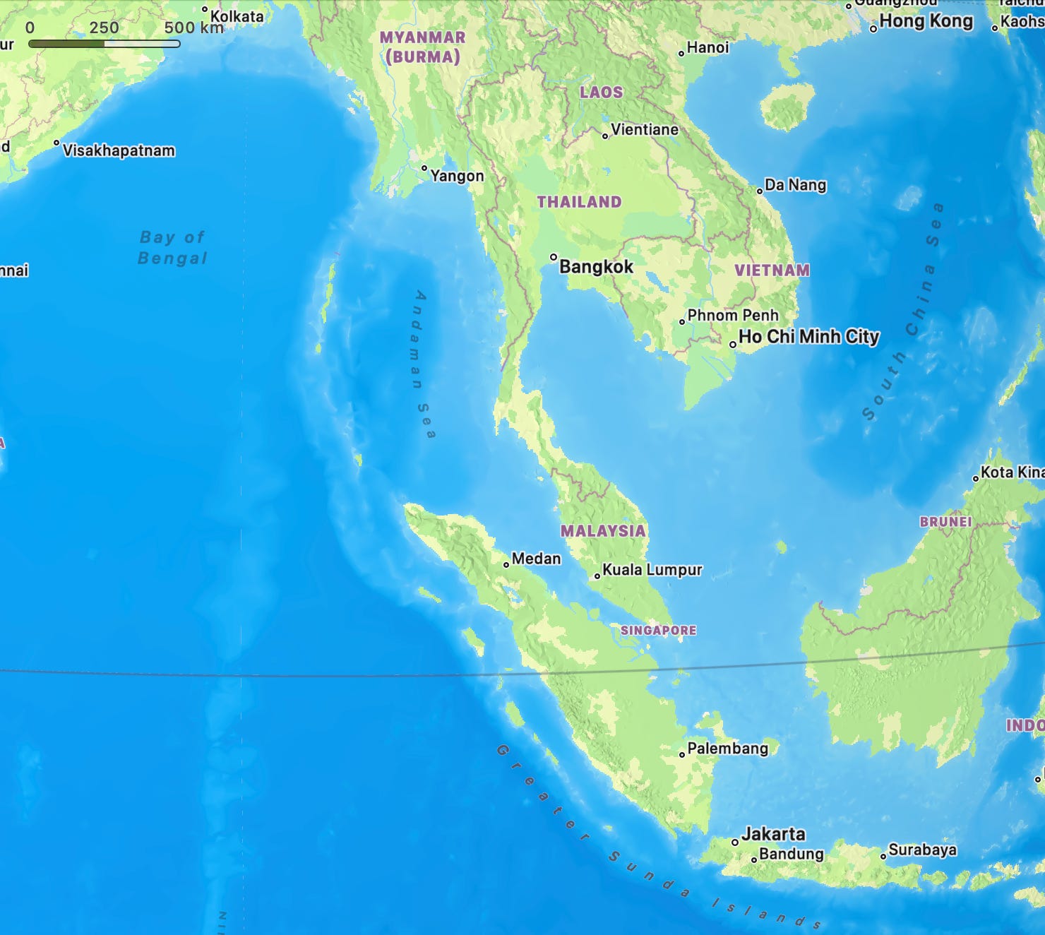
Singapore is not some random location in the world. If we zoom in on the map, you can see that all merchant ships naturally have to pass Singapore if they are going between East and West.
I remember when reading the starry eyed account of the Singapore economic miracle, they mentioned the challenges with an ethnically diverse population of Malay, Indian, and Chinese. That ought to set off some alarm bells. Cities back in the 1950s would not randomly be ethnically diverse. Diversity is nearly always a sign of a place with economic opportunity. Places with get immigrants because there are economic opportunities there.
Long before British colonization, the Malay Peninsula was a hub for regional trade involving Indians, Chinese, Arabs, and other Southeast Asian groups. Singapore, then known as Temasek, was already a minor trading post with regional connections.
The British when colonizing Singapore in 1819 only furthered this policy. Different immigrant groups came for different reasons:
Chinese: The Chinese were already dominant in regional trade and were encouraged to migrate as laborers, artisans, and merchants.
Indians: The British brought Indian workers to build infrastructure and serve in administrative roles, as well as traders from southern India.
Malays: The native Malay population was supplemented by migrants from the surrounding Malay Archipelago.
Arabs and Others: Arab merchants were drawn to Singapore due to its role in the spice trade and the free port’s opportunities.
For the history interested, it might be curious however that Singapore was no major city of importance until the British colonized it. There are several reasons for that.
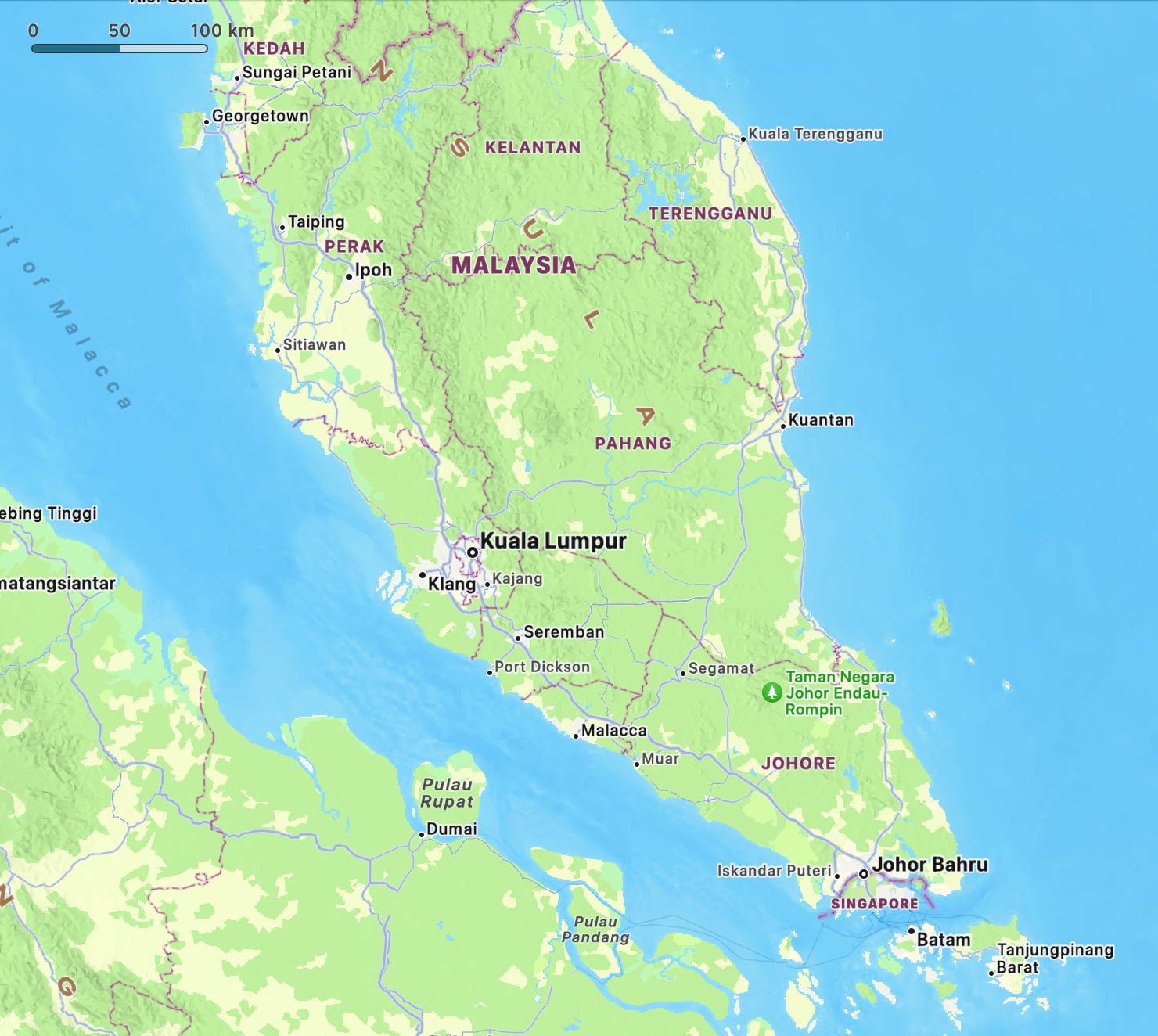
Malacca further up was long a more important city than Singapore. It connects to the Melaka River, which gave it a larger hinterland to source goods from the interior of Malaysia. Singapore, in contrast, only has a short river which does not give it access to much hinterland.
The Dutch arriving in Asia before the British had already ceased it. That left Singapore for the British. Being at the mouth of a river, however has advantages and disadvantages. Larger rivers move a lot of sediment. These sediments get deposited at the mouth of the river leading to shallow harbors.
Singapore had a deep natural harbor, making it well-suited for accommodating larger, deep-draft ships that became increasingly common in the 19th and 20th centuries. The British controlled coal mines in India and used this to build up Singapore as a coal station. They invested heavily in infrastructure for storing and managing coal.
As steamships became increasingly important, this gave Singapore a major edge over the competition. For large steamships, Singapore was a superior harbor. It was deep enough to handle such ships and allowed them to refuel.
Here we can talk about path dependent development. Once extensive infrastructure for large ships is established, there becomes a vested interest in growing infrastructure with trade development. As the economy of Japan, China, and India boomed, Singapore would naturally profit. The increasing trade between Europe and Asia had to go through Singapore.
Singapore naturally expanded on the coaling strategy by becoming an oil bunkering hub. So as ships transitioned from coal to oil, Singapore did the same by building large oil storage facilities. Singapore is a key trading hub for oil. Since oil has to transition in and out there, they could take advantage of this fact by building a petrochemical industry to refine oil. The traders are already there.
It is all about location. A city like Bangkok or Jakarta could not have copied the Singapore strategy because ships going between Europe / Middle East and Asia are not forced to pass either of those cities. In fact, they would be big detours.
")
Prosperity of 1600s Amsterdam
Let us look at the city which was perhaps the richest city in the world in the 1600s in the period referred to as the Dutch Golden Age. Why was the Netherlands in that time so rich? They had no valuable mines. The soil wasn't very well suited for growing grain as it was so wet.
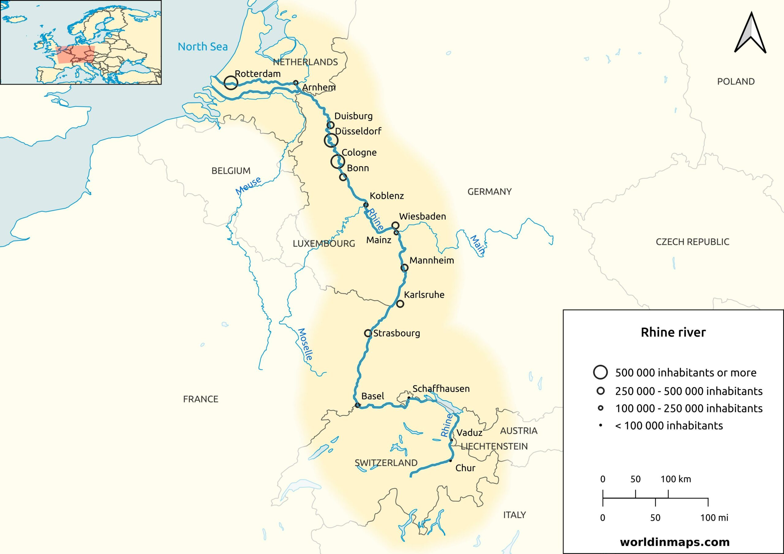
Instead, the Netherlands is essentially the river delta for the Rhine river. Perhaps the most important river in Europe. The river basin or hinterland of the Rhine covers large parts of Germany and the Netherlands. Thus, goods to and from Germany and Switzerland would have to travel through the Netherlands. In other words, the Netherlands is a gateway to European markets. Several other significant rivers end in the Netherlands, such as the Meuse and the Scheldt.
Thus, to ship your goods to large parts of Germany, France, and Switzerland you would have to enter a Dutch city such as Amsterdam. What made the Netherlands extra well suited as a trading hub is that because it is below sea level, it is relatively easy to dig canals there. Canals make bulk transportation cheap. The Netherlands utilized this to create manufacturing centers.
Like many other places in Europe, the Netherlands has a lot of peat. However, in most places, peat is expensive to transport. But the Dutch could just dig canals to peat fields and load peat onto canal boats. Thus, large quantities of peat could be transported cheaply. Peat provided fuel for thermal processes. Beer brewing, sugar refining, alcohol distilling, brick making, glassmaking and salt production are all essentially thermal processes which benefit from access to cheap fuel like peat.
The Dutch used their windmills for other processes, such as processing timber to make furniture and ships for export. Mills would also grind grain into flower, crush various seeds into oils, beat linen rags into paper, chalk and lime grinding. Tobacco from colonies would be ground into powdered snuff. Spices would be ground into powders. Indigo and logwood from the Americas would be ground into dyes.
So the Netherlands did something similar to Singapore. It set up refinement processes for imports that had to go through their cities. Remember, Singapore built a petrochemical industry because oil would get stored and traded in Singapore.
Southern European cities in the Mediterranean could never have gained this position because there are no major European rivers exiting in the Mediterranean. They primarily exist in the North Sea and Baltic Sea. This is part of why Venice, which had been a major maritime power, fell behind Amsterdam. Amsterdam could source timber for ship building from Germany, the Baltics and Scandinavia.

London in the 1800s
What made London overtake Amsterdam in importance in the 1700s and 1800s was much the same reason as Malacca lost to Singapore in the 1800s. The Rhine brings a lot of sediment which means Dutch harbors had problems with silting up and having shallow waters. Dutch ships were built to not go very deep in water for this reason. As the size of ships started increasing London became a more favorable city. The Thames is deeper, allowing for larger ships. London is placed such that you can go all the way up to London only using the tides.
Placing the harbor inland had many advantages. It put the city far from destructive storms and pirates. England, like the Netherlands was well suited for canal building. This was in part due to moderately sized rivers and consistent rain throughout the years ensuring canals would have water all through the year. Canals made it possible to transport goods from large parts of the country to London.
London may not have direct access to as large hinterland as Amsterdam but it was a much better harbor which made it better suited as the capital of an overseas colonial empire.
Most other European capitals did not have this advantage. Ships could not easily go up the Seine to Paris for instance. Also other capitals were not connected to a large network of canals which could transport coal, iron and other bulk commodities to the City.

Aztec capital Tenochtitlan on lake Texcoco
Hernan Cortés arrived in Tenochtitlan on 8 November 1519. Although there are no precise numbers, the city's population has been estimated at between 200,000 and 400,000 inhabitants, placing Tenochtitlan among the largest cities in the world at that time. Compared to the cities of Europe, only Paris, Venice, and Constantinople might have rivaled it. It was five times the size of the London of Henry VIII.
Hernan Cortés would go on to elaborate on the splendor, size, organization, and architecture of Tenochtitlan in letters to the Spanish king. What is remarkable however is how this city defied everything we assumed about cities. It was not by a major river or on the coastline like most large European cities. In fact, Mexico has no major cities on its coastline, which seems puzzling. Singapore, Amsterdam, and London, which I have discussed, all derived their size from their ability to act as transportation hubs.

In some ways, Tenochtitlan did that as well. The city was located in lake Texcoco which around half the size of Salt Lake back in 1519. This lake was connected through rivers and canals to other lakes. This allowed effective transportation of goods to and from all towns and cities along any of these lakes or rivers using canoes.
But why isn't the city by the coast as is common elsewhere? In fact, Tenochtitlan which is at the site of modern-day Mexico City, is within the small area that contains 50% of the whole population of Mexico. This area only represent 8% of all of Mexico.
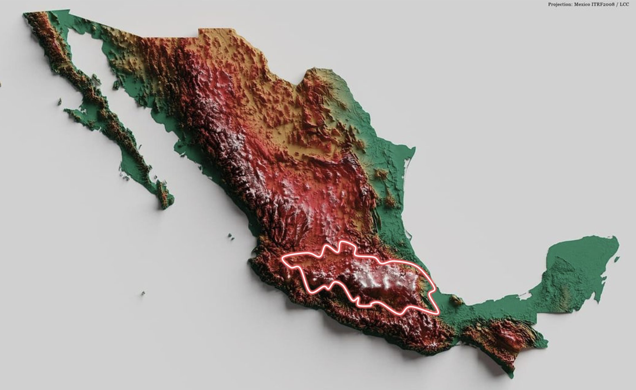
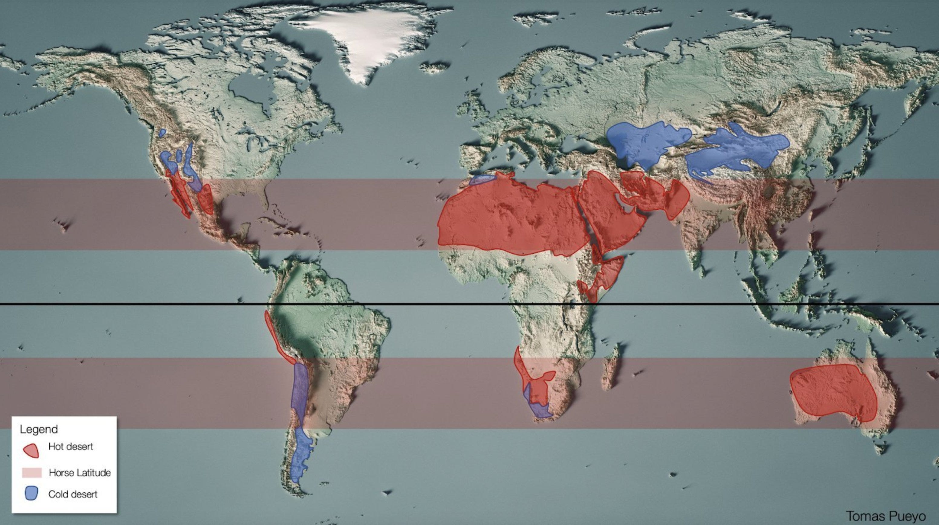
Tomas Pueyo has a great thread on X on why this is. In fact, I borrow some of the images he used there in this article. It is located in what is called the horse shoe latitude. These areas tend to have a lot of desert. It is the same latitude as Sahara.
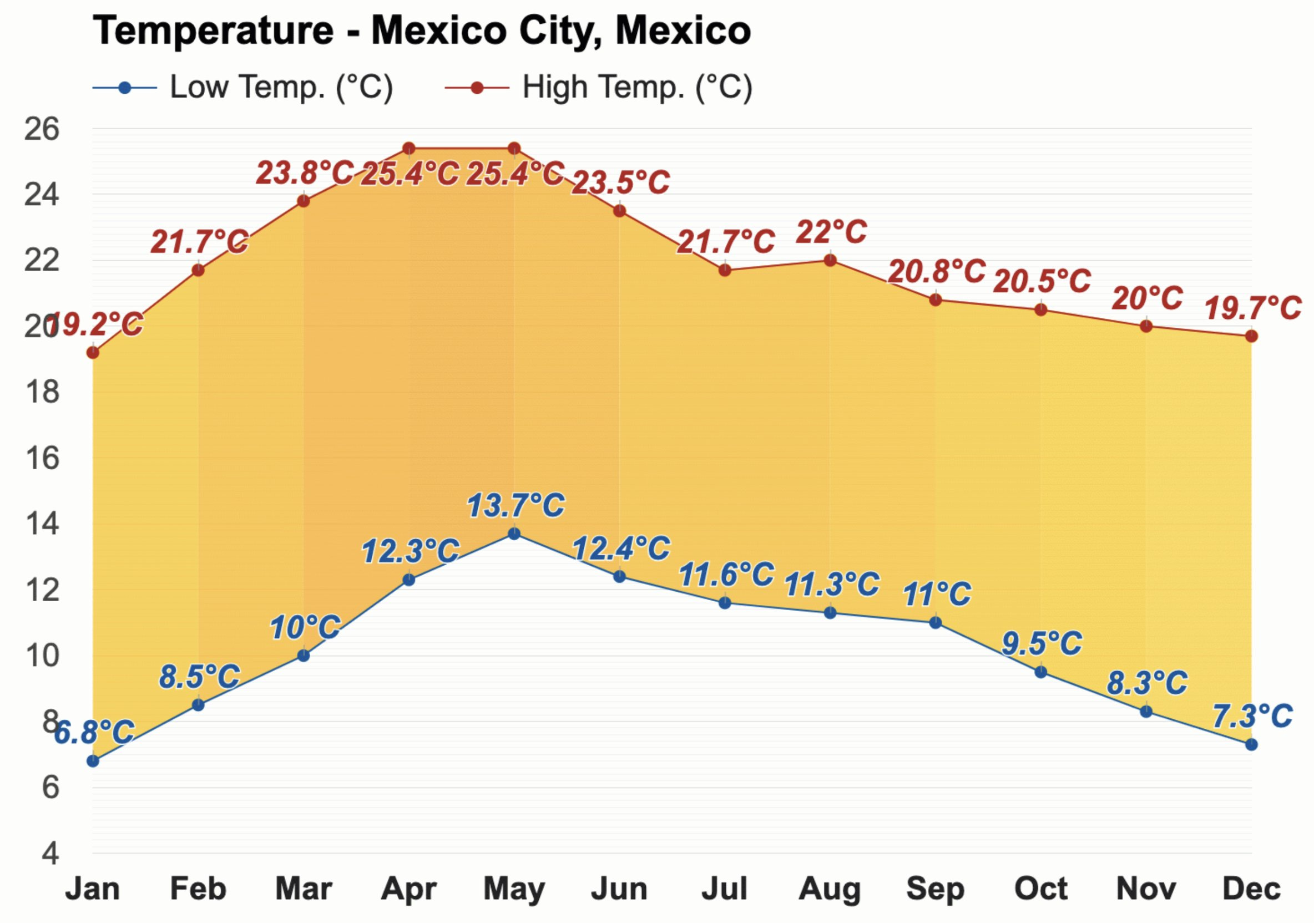
Why would anyone live in the middle of the Sarah? Temperatures fall with latitude. That is why at such a latitude there is a great advantage to living at high altitude. Due to the altitude Mexico City actually has a very moderate temperature all through the year.
It is also an area with plenty of volcanoes and volcanic activity. That has left layers of volcanic ash, which gives very fertile soil. In fact, This is one of the areas of the world with the most fertile soil. Now we get a sense of why so many people live in this area. The area has a pleasant climate, great soil and mountains in the area provide water to lakes which help support agriculture. The Aztecs created a unique system with "floating islands" made of mud and branches to grow crops on called Chinampas.

The Aztecs used a three-crop rotation system (maize, beans, and squash), which maximized land productivity while maintaining soil health. Chinampas were so efficient that they could feed up to 15 people per hectare, much higher than typical European agricultural systems of the time.
In Europe during the early 1500s, the agricultural productivity of a hectare was significantly lower than that of the Aztec chinampas. Estimates suggest that European farming techniques at the time could feed around 3 to 5 people per hectare, depending on the region, the type of crops grown, and the farming methods used.
So there were plenty of benefits to the area that the Aztecs centered their civilization. There were however other practical limitations. Due to the high-temperature, rivers would dry out before they could reach the coast. In other words, typical European cities at the mouth of rivers were not possible in Mexico.
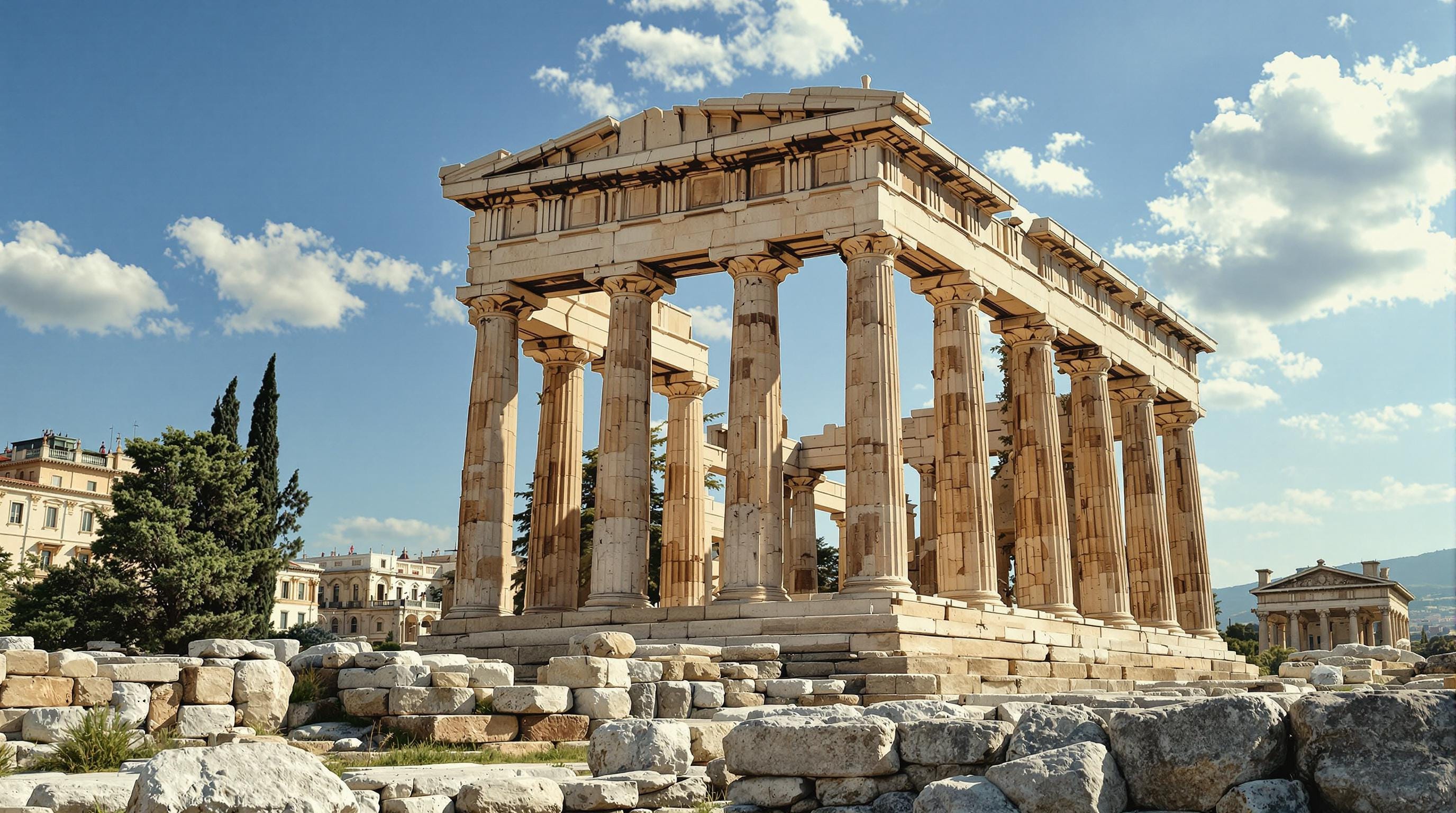
Ancient Athens
In the ancient world great civilizations typically arose along larger river systems: Egypt along the Nile, Sumer and Babylon along Euphrates and Tigris, China along the Yangtze river and so on.
Read more: When Greece Had a Larger Population Than Africa and Japan Combined
Ancient Greece was interesting historically because in its time it was the richest place on the planet despite not being built around high productivity agriculture such as the Aztec empire, Sumer, China or Egypt. Rather it built its prosperity on trade and specialization. Athens is an excellent example of this. Like Singapore it built its wealth primarily as a maritime trading hub as opposed to having rich resources. Okay that isn't entirely true as they did have rich silver mines which complicates that narrative. But regardless let us dig into the foundations for Athenian prosperity.
The Aegean Sea as a Maritime Highway
The Aegean Sea acted as a particularly efficient maritime "highway" in the Mediterranean due to a combination of geographic, climatic, and navigational advantages.
1. Geographic Features
Island Density:
The Aegean is dotted with numerous islands, such as the Cyclades, Dodecanese, and Sporades. These islands are spaced relatively closely, providing sailors with frequent stopping points for resupplying, shelter, or trade. This reduced the risk of long, open-sea voyages compared to the broader, more open western Mediterranean.Indented Coastlines:
The Aegean's coasts are deeply indented, creating numerous natural harbors that could accommodate ships. This made coastal navigation safer and facilitated trade between city-states and regions.
2. Navigational Stability
Predictable Winds:
The Aegean benefits from the Etesian winds (seasonal north winds that blow in the summer), which were both a challenge and an advantage. While these winds could make sailing difficult in certain months, experienced mariners used them to navigate efficiently, especially when heading south.Calmer Seas (Relative to the Open Mediterranean):
Although the Aegean can experience rough conditions, it is generally more protected compared to the larger Mediterranean basins. The islands and narrow passages act as buffers, reducing the impact of open-ocean swells.Shorter Distances:
The relatively short distances between islands and coastal settlements made it easier to navigate even in less favorable weather, as mariners could often see land and adjust course.
3. Economic and Political Factors
High Concentration of City-States:
The Aegean region was densely populated with city-states (Athens, Ephesus, Rhodes, etc.) and trade hubs. This created a vibrant network of commerce that relied on maritime routes for the exchange of goods like grain, wine, olive oil, pottery, and luxury items.Strategic Crossroads:
The Aegean connected important trade routes between the eastern Mediterranean (Egypt, Levant, and Persia) and the western Mediterranean (Italy, Carthage, and beyond). This centrality enhanced its role as a conduit for goods and ideas.
The Aegean Sea's unique geography—its dense islands and accessible coastline—was its defining advantage as a maritime highway. While other areas of the Mediterranean had navigational and trade potential, the Aegean stood out for its combination of safe, short-distance travel and a dense network of trade-oriented communities. This made it a hub of economic and cultural activity, surpassing other Mediterranean regions in terms of maritime accessibility during the classical period.
New York City
If you read along thus far it will probably not surprise you what drove the success of New York. It boasts one of the world’s best natural harbors. The deep waters of New York Harbor provided safe anchorage for ships, enabling it to become a major trading hub. Its location shielded it from the harsher Atlantic conditions, making it an attractive port for transatlantic trade.
It has a very strategic coastal position:
Positioned on the eastern seaboard of the United States, NYC served as the gateway for European goods and migrants entering the New World.
Proximity to Europe (shorter sailing routes compared to other US ports like Charleston or Savannah) allowed it to dominate trade during the colonial and post-colonial periods.
And just like Amsterdam New York could pull in resources from larger areas by being placed at the mouth of several rivers.
Hudson River - The Hudson provided a navigable waterway deep into the interior of New York State, connecting NYC to fertile lands and emerging industrial centers upstate. This made it a vital artery for moving goods and people.
Erie Canal (1825) - The construction of the Erie Canal connected the Hudson River to the Great Lakes, transforming NYC into the primary trade hub for the interior United States.
The Erie canal was a big deal since it allowed goods to flow efficiently between the Atlantic Ocean and the Midwest. This solidified NYC's dominance over other ports like Boston and Philadelphia.
Conclusion
There are many ways in which people misunderstand the source of economic prosperity for different nations or cities. The first mistake people make is assuming prosperity is purely about resources—believing that countries are rich because of gold mines, coal, oil, spices, or some other natural asset.
Most people, upon looking more closely at the world, realize this isn’t the case. They can see that places like Singapore, Japan, and many others are rich despite lacking an abundance of natural resources. This even applies historically—Ancient Greece, for instance, wasn’t wealthier than other places because of rich soil or abundant resources.
But after this realization, people often fall into a second, equally common misconception: they think wealth comes from superior culture—believing that prosperity arises from being more hardworking, innovative, or clever. This is the mistake often made about Singapore, assuming it built its wealth simply through hard work and smart policies.
By this logic, one might claim the Netherlands in the 1600s was the richest place in the world because the Dutch were simply smarter than everyone else. But as I argue in this article, that’s fundamentally wrong.
The prosperity of these cities came from their unique geographical advantages, which made them transportation and trading hubs. Wealth and prosperity stem from being located where large volumes of goods can flow easily.
Of course, political and economic choices still matter. But here’s the kicker: Athens in the 1600s couldn’t have achieved the economic success of Amsterdam simply by copying its policies. Similarly, Lagos cannot replicate Singapore’s wealth by adopting its practices. It lacks Singapore’s unique geographic location.
Ironically, the first assumption about resources isn’t entirely wrong. While wealth doesn’t depend on directly controlling resources, it does matter what resources and goods can flow through your cities. For example, if Germany, the UK, and Norway were removed from the map, the Netherlands couldn’t have become rich. Cities like Amsterdam and Rotterdam built their prosperity on being gateways to Germany—a country not only rich in resources like forests but also home to large population centers that consumed goods. Norway provided the Dutch with timber for shipbuilding and fish to sell in European markets. Further back in history, the Dutch relied on English wool for their thriving textile industry.
Likewise, Ancient Greece could not have achieved its wealth without trade with Egypt, Anatolia, and the Black Sea region. The rocky soil of Attica couldn’t produce enough grain to feed its population. Athens compensated by focusing on specialized products like pottery, olive oil, and wine for export. Its geography provided access to high-quality clay for pottery, and while its soil wasn’t ideal for grain, it was well-suited for olives and grapes.
Without access to sea-based transportation, Athens would have been forced to use its limited land for grain production, yielding poor results and leading to poverty. The Dutch made similar choices. Their wet, low-lying lands weren’t suited for growing grain but were excellent for grazing livestock. Milk, like grapes, is not durable. To make it exportable, the Dutch turned it into cheese, just as the Greeks turned grapes into wine to increase their products’ durability.
In other words, natural conditions that might otherwise make your lands poor can lead to prosperity—if you have access to trade. This is why cities connected to efficient water-based transportation have always enjoyed economic success.
Great post! Typo; "Dutch had ceased" should be seized.